


 General Assembly
 Security Council
11
Dispatch → Factbook → Geography
by  The Protectorate of Urkhuz.
.
701 reads.
The Protectorate of Urkhuz.
.
701 reads.
Maps of Albastru

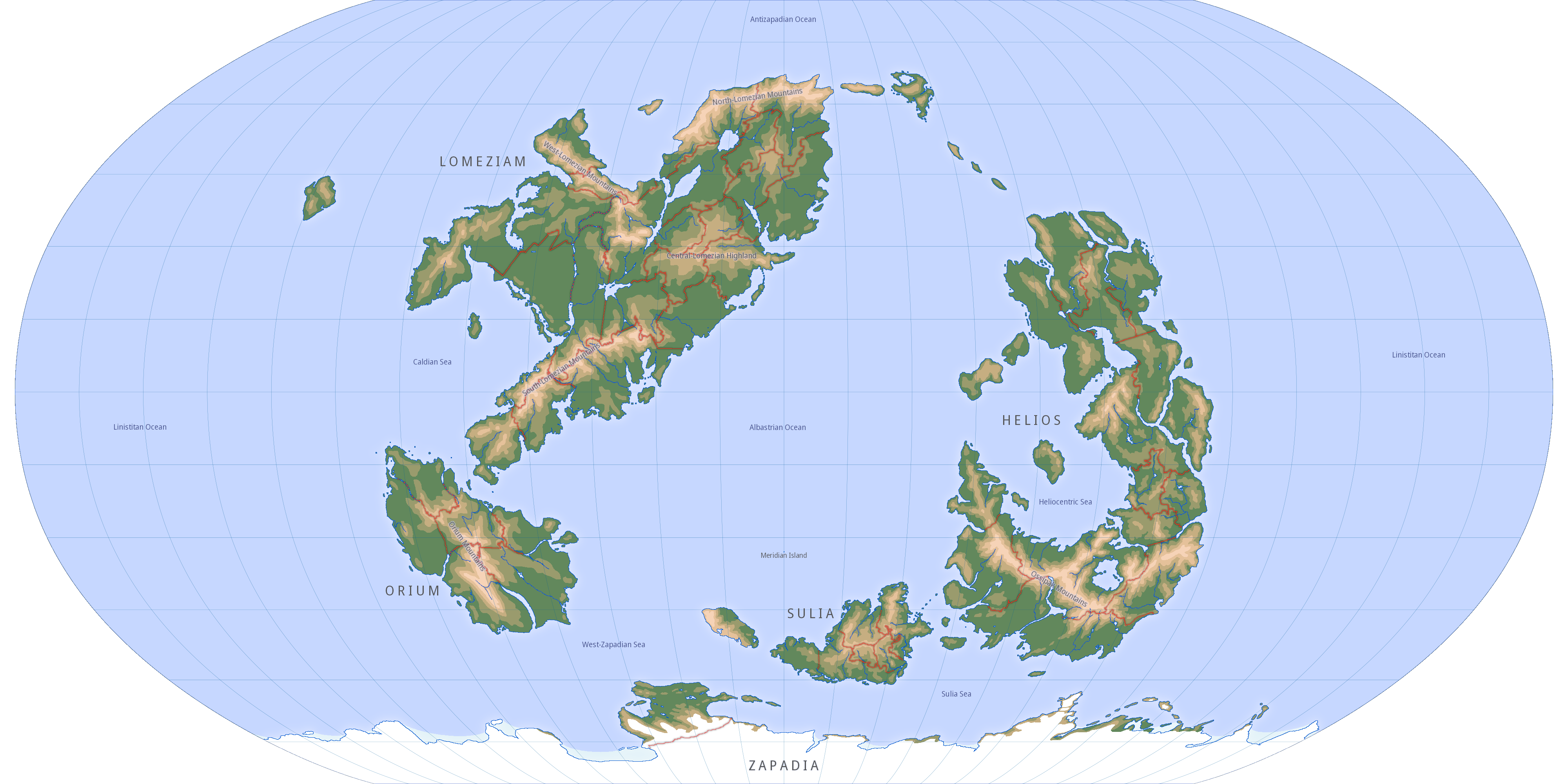
(Click on the map to open a full size image in a new tab.)
map key:
: 0–500m
: 500–1000m
: 1000–2000m
: 2000–3000m
: higher than 3000m
Notice that these height indications do not mean that all of that land is in those height ranges. What it means is that hills or mountains in these areas typically have peaks in those height ranges. For example, land in this color will be mountainous with peaks between 2000 and 3000m. There can be an occasional mountain peak in such an area that is a little bit higher, however. And valleys will be much lower, of course.
Zooming in on part of the world map does not result in accurate country maps due to map distortion. Maps of individual countries will be provided on request.
Climate Maps
Köppen Climate Classification
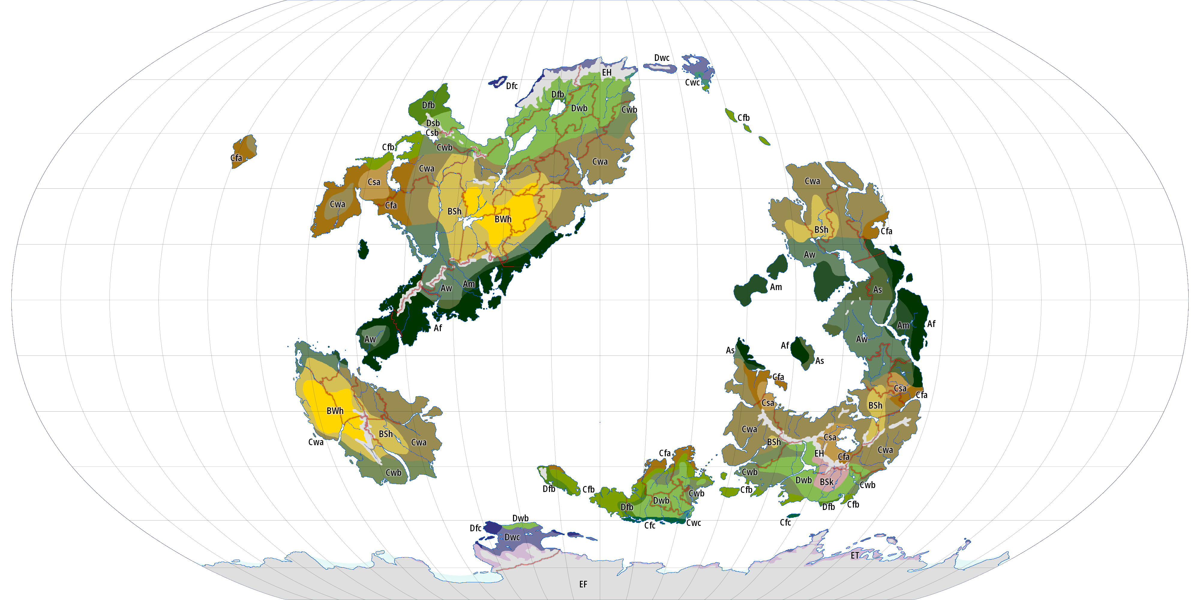
(Click on the map to open a full size image in a new tab.)
The first, capital letter in the Köppen climate classification stands for the general type of climate. More about that below. The second letter is often a lower case f, s, or w. The first of these means that there is precipitation in all seasons. s and w normally mean dry summer and dry winter, respectively, but here they mean relatively dry summer or winter. There are precipitation maps below. If an area is "dark" yellow on those maps (i.e., not light yellow) then it is dry in that season. (Notice that on those maps, "northern winter means southern summer" and the other way around.)
A climates are tropical. Af is tropical rain forest. As and Aw are savanna with dry summer and winter, respectively. Am is monsoon climate, strictly speaking, but Albastru lacks the conditions for monsoons and here it just means that the climate is between Af and adjacent As or Aw.
B climates are dry. BW is desert. BS is steppe. h or k means hot or cold. There is no cold desert on Albastru, but there is a cold steppe (BSk) on southern Helios.
C climates are temperate. For C climates the second letter refers to precipitation as explained above, and the third letter to temperature. a is warm or sub-tropical. b is moderate. c is (relatively) cold or even sub-arctic.
D climates are continental climates, or variants of C climates with colder winters (at least one month with an average below 0°C).
E climates are polar and alpine climates. ET is tundra. EF is ice cap. EH is an obsolete classification for alpine climate, which really is a mixture of EF and ET at greater heights and various D climates at lower heights (i.e., in valleys), but on the scale of a world map that is impossible to show.
The unmarked light blue touching Zapadia is ice shelf. Floating sea ice isn't shown as this varies a lot (especially seasonally). There is floating sea ice around Zapadia and also at the north pole (Antizapadia).
Precipitation in Northern Winter

(Click on the map to open a full size image in a new tab.)
Yellow on this and the next map means (almost) no precipitation in that season. (Notice that on these maps, "northern winter means southern summer" and the other way around.) Light yellow means little precipitation; light blue some precipitation; and blue a lot of precipitation. Whether this precipitation falls as rain or snow depends on season and latitude.
Precipitation in Southern Winter

(Click on the map to open a full size image in a new tab.)
Prevailing Wind and Pressure in Northern Winter

(Click on the map to open a full size image in a new tab.)
Orange/yellow is low pressure; blue is high pressure.
Prevailing Wind and Pressure in Southern Winter
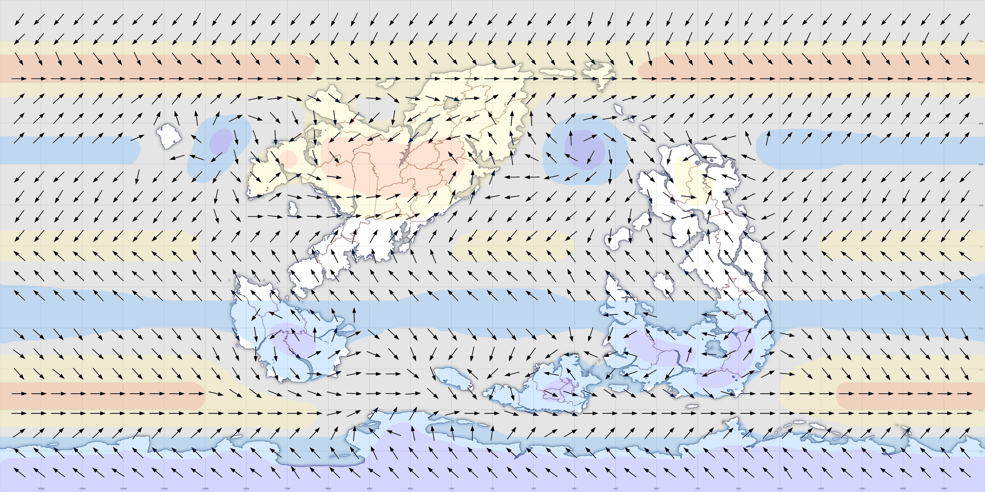
(Click on the map to open a full size image in a new tab.)
Surface Currents

Thermohaline Circulation
Other Maps
(time zone map to be added, eventually)
See also:
Area and Population Data of Albastran Territories.
Official RP maps. (The latest/current version can be found on the region page.)


