


«12. . .1,8231,8241,8251,8261,8271,8281,829. . .2,6462,647»

Hey guys, I finally wrote a little factbook about Ruinenlust. I'm not very good at putting lore down into words, since I never know where to start. But if anyone is feeling bored, it's not too long. This is sort of an "overview," but I put it under "geography," since that is what most of it discusses. :-)
The biogeography of Ruinenlust is currently characterized by large, temperate forests in lower elevations and southern locations, transitioning to boreal forests as the elevation and latitude increase, with alpine regions and tundra refugia on the highest mountain ridges and plateaus of the northern regions. Forests often have several feet of humus underfoot, covered in mosses and lichens, along with myriad delicate herbs and flowers, at least where shafts of sunlight allow for such growth. In valleys that are shielded from the storms off of the ocean, the trees become truly gigantic, and form a tall canopy. The forest floors are dim in the summertime, when the leaves form near-continuous shade.
The climate of Ruinenlust varies greatly by location, and ranges from temperate to boreal to tundra, as one goes farther north and/or uphill from the southern coast. While an island nation, the climate also becomes more continental in the interior. Rainfall is evenly spread throughout the year, and any given location seldom goes more than a week without precipitation. Coastal areas, especially to the west and the north, receive near-daily precipitation, and for that reason, those regions are devoid of permanent human habitation. Given the climate and terrain, Ruinenlust is covered in many streams and rivers, many of which feature spectacular waterfalls and cataracts.
In modern times, the human population mostly inhabits the central region, in a place where several mountain ranges end and where a number of rivers converge, in an area of relative flatness. The population has declined significantly from a few centuries ago, when much of the country was extensively affected by rampant development and expansion of infrastructure. A series of human-amplified "natural" disasters, combined with profound shifts in cultural values and attitudes, led to the voluntary depopulation of much of the land, along with efforts on the part of the government to maintain better standards of living for those who remained. Many inhabitants chose to either be childless, or else to have only one or two children, and the widespread abandonment of cities, towns, and infrastructure throughout much of the country eventually created a new name for the country, Ruinenlust (i.e. "the love of ruins").
Citizens were encouraged to relocate to a new city, Dendropolis (The City of Trees), where the slight majority continue to live to this day. The country rejects modern notions of "progress" and "growth," instead focusing on things such as personal fulfillment, happiness, and caretaking of the natural environment. The environment of Ruinenlust is considered to be a beacon of hope for an increasingly overpopulated and destroyed world, and is the premier example of the tenacity and rejuvenation of nature that is possible when humans voluntarily limit their own numbers and prioritize the rest of the biosphere above their own short-term accumulation of wealth.
More to follow... :-)
Murmuria, Kawastyselir, Alcantaria, Octopus islands, and 9 othersAtsvea, Lord Dominator, Auphelia, Turbeaux, Rivienland, Northern Wood, Hobbes dystopia, Middle Barael, and Forestal
Welcome to Forest. My nation is almost none of those things.
Octopus islands, Mount Seymour, Atsvea, Ruinenlust, and 6 othersLord Dominator, Turbeaux, Northern Wood, Hobbes dystopia, Middle Barael, and Forestal
I don't mind the stat changes, I just hate the unblockable "laws have been enacted to bring X into compliance with Popular Player's New Rule Of Law Of Law" telegrams.
Murmuria, Atsvea, Ruinenlust, Lord Dominator, and 3 othersTurbeaux, Northern Wood, and Middle Barael

So, the UK is going to make wearing a face mask in shops mandatory.
As someone in the UK who has worn a face mask in public continuously since the outbreak, I can't believe its taken us so long to get to this point. As a country we've been really bad at this, even more so than the US:
https://ichef.bbci.co.uk/news/624/cpsprodpb/856B/production/_113355143_optimised-yougovcorona-nc.png
It was just such an obvious thing to do, as a measure that has no economic harm (and probably even has economic benefit, as it gives people more confidence to go into public spaces) and has a proven effect in significantly reducing transmission.
I swear that the UK government's approach has largely been built around trying to avoid talking about coronavirus as much as possible. It's so very British - keep a stiff upper lip, and for gods sake, don't mention the embarrassingly deadly disease, people will think we're "common".
Murmuria, Jutsa, Atsvea, Ruinenlust, and 11 othersLord Dominator, Auphelia, Turbeaux, Northern Wood, Roless, Eco-empire, Hobbes dystopia, Hwayang, Pythaga, Middle Barael, and Forestal
Don't beat yourself up, nobody in the world has been worse at this than us.
Cameroi, Murmuria, Jutsa, Atsvea, and 6 othersRuinenlust, Lord Dominator, Turbeaux, Northern Wood, Eco-empire, and Middle Barael
You know you can stop that, right? Go to Telegrams, click Preferences, and you can turn it off.
Pretty much all notifications in NS are toggle-able.
Atsvea, Ruinenlust, Lord Dominator, Auphelia, and 3 othersTurbeaux, Northern Wood, and Middle Barael

By us, you mean US, right? Nobody is worse than the Great Old United States of America!
But then again it makes perfect sense considering who is in charge of our government.
I have a question regarding role-play in the region. I know that this is not an RP region, but we do have a regional map, and so Im hoping someone can answer this. Firstly, does Forest have a regional capital? Id assume it would either be in Errinundera, Ransium, or Verdant Haven, but it has never really been brought up. If not, can we select a city to be our capital? Perhaps choosing a city from those 3 above nations, or maybe wed have the capital be decided from a vote or have it revolve.
Secondly, are there names for the seas and oceans on our regional map? And is the main continent just called Forest? The names for the seas/oceans I think should stick with the tree theme, but if they already have names, please let me know.
Finally, why are there arrows pointing to other regions when half of those other regions dont even have regional maps!? Haiku doesnt, I dont think IDU does, and one of the regions (I think its Yggdrasil but I forgot) has a map but it would in no way be able to connect to our map. Are they just there for show?
Thank you
Alcantaria, Octopus islands, Atsvea, Ruinenlust, and 4 othersLord Dominator, Auphelia, Turbeaux, and Northern Wood
I can't answer most of these unfortunately (I didn't make the map, just update it), but hopefully these maps by Bruination can point you towards the right direction for a few of your questions:
NOTE: Before asking questions about the map, please read the entire section below titled How to Get on the Map. If you don't find answers to your questions here, please telegram the cartographer, Bruination, instead of asking on the regional message board (RMB).
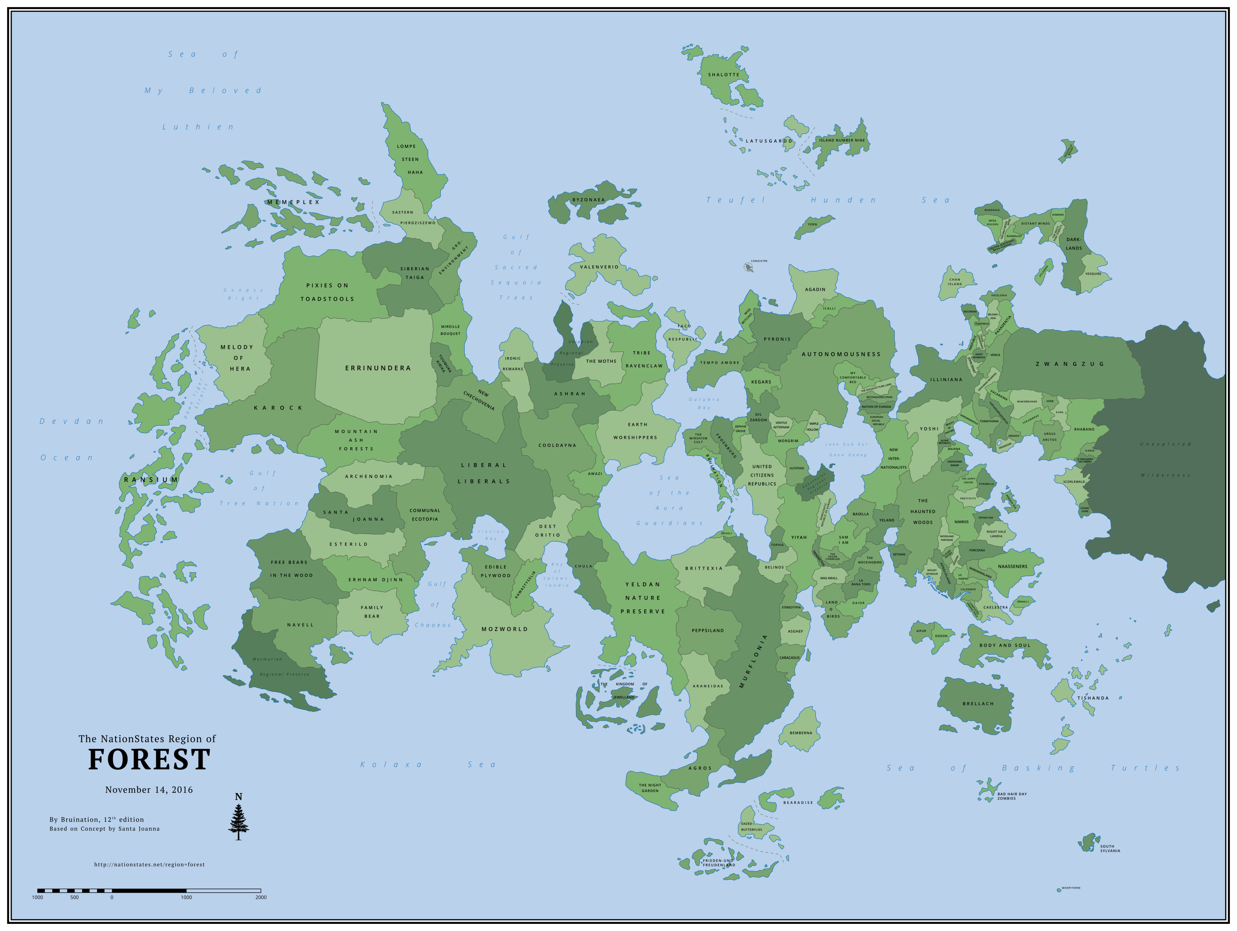
Introduction Forest's regional map is one of the largest on NationStates and differs from most in a few key ways. It is not an opt-in map on which nations must request inclusion. Nations are automatically added as long as they meet certain criteria based on the nation's participation in the region. Forest's map has two main functions: Firstly, it uniquely serves as a timeline of when each nation first arrived in Forest, with the earliest arrivals positioned to the west and the latest to the east. Secondly, it illustrates every nation's relative population, with more populous nations occupying more land area. The land and coastline evolve with each new update, as nations arrive, grow, or depart. The map is not primarily a role-play tool, although it can be used as one.
The original map series of Forest was begun by Santa Joanna in February 2012 and continued until September 2014. After a year with no further updates, Bruination began work on reviving the regional map with a new layout and style, while honoring the traditions set by Santa Joanna of using the map as both a timeline and a representation of population size. The first edition of Bruination's series was released in November 2015. By June 2016, the map had grown to depict 151 nations, the highest number on any known regional map on NationStates at the time. |
Contents |
Changes in This Edition:
Added (18)
Arbb, The misty pine forests, Euna, Purabella, Tishanda, Rhabano, Eumangi, Scorlewald, Monpiterre, Nouvelle bouef, Darklands, Le parlement des arbres, Vesquire, South sylvania, Bondaisia, Hazelonia, Cosireshire, IcareaExpanded (21)
Mount Seymour, Prettycity, Woodland partisans, Wise Witches, Nimros, Mireille bouquet, Stereotypia, Okefenokee swamp, Peppsiland, Ulfstead, Belgianadia, Eryndlynd, Gil zardon, Mag meall, Terumbrae, Agadin, Democratic republic of europa, Tempo amore, Aengloland, Chan island, The MothsRemoved (11)
Delionera, Oecos, Shilmesta, New Lvsitania, Idryll, Lebowskiberg, Walquiria, Leafapolis, Nonus The Hobo, Crasterram, ElfendelTotal Nations: 171
Previous Edition: 164
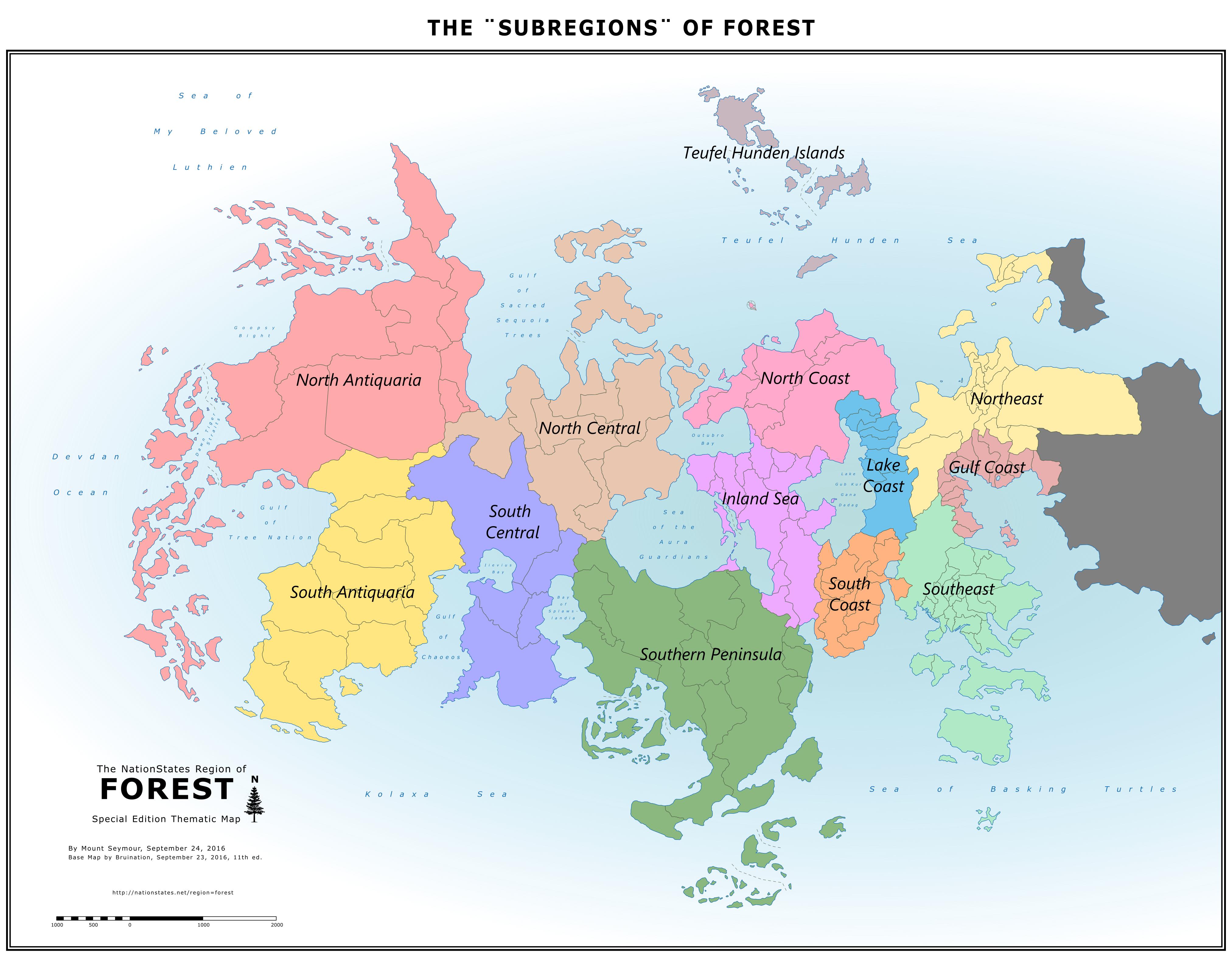
The "Subregions" of Forest |
The Greenest Nations in Forest By Mount Seymour |

How to Get on the Map
Please read this entire section before asking questions about the map.
If you don't find answers to your questions here, please telegram the cartographer, Bruination, instead of asking on the regional message board (RMB).
Every nation that moves to Forest has the opportunity to be automatically added to the map. Asking to be put on the map is not the way to get on it. The map eligibility criteria is designed to reward and encourage active participation and longevity with inclusion on the map, meaning nations that move to the region and remain inactive are unlikely to be included.
Map Eligibility
After joining Forest and remaining in the region for 30 consecutive days, a nation will be evaluated for map eligibility based on the following:
At the time of evaluation, the nation must have signed in within the last 15 days AND meet one or more of the following criteria:
1) It is a WA member and has endorsed the regional delegate; OR
2) It has contributed to discussions* on the regional message board (RMB) in the last 30 days; OR
3) It has registered for the  off-site forum and has posted at least once in the last 30 days; OR
4) It has at least 1 billion citizens and has addressed at least 12 issues in the last 6 days.
* This is the most subjective of the criteria. Generally it means RMB posts with content and value. One good post may have enough, whereas a dozen posts of little substance may not. Spam is highly discouraged.
Once a nation is determined to be eligible, it will be marked for inclusion in the next map update, which may occur some weeks later. (Map update frequency currently ranges from about 4 to 8 weeks.)
During the wait to be included on the map, take some time to read Forest's newspaper, the Forest News Leaf, or even write an article! Contact Forest's publicist, Frieden-und Freudenland, for more details.
Second & Third Chances
A nation will immediately be given a second 30-day waiting period, followed by a second evaluation, IF:
1) It fails to meet any of the above criteria at the time of its first evaluation; OR
2) It departs or ceases to exist (CTEs) for any amount of time during its first 30-day waiting period and then returns.
A nation will immediately be given a third 30-day waiting period, followed by a third and final evaluation, IF:
1) It reaches 1 billion citizens after it failed its second chance; OR
2) It requests a third chance (but not a fourth) by sending a convincing telegram to the cartographer.
If a nation fails its third and final evaluation or departs or CTEs during its third waiting period, it forfeits its opportunity to get on the map.
Removal from the Map
Once a nation is already on the map, future changes to the above criteria will not affect it. A nation will usually only be removed from the map for one or more of the following reasons:
1) It ceases-to-exist (CTEs) and does not return within 60 days; OR
2) It departs Forest for another region and does not return within 10 days; OR
3) It requests removal.
A nation that has been removed from the map for CTEing or departing is treated as a new arrival if it returns to Forest, with a new set of three chances to become eligible again. However, at the cartographer's discretion, a nation that has been added and removed repeatedly may run out of chances to be re-added again in the future.
How the Map Works
In order to leave much up to the imagination, there is no reference to an exact scale or latitude. The scale in the bottom left corner does not specify a unit of length and is purely decorative. The position of an equator and/or polar circle(s) can be imagined anywhere on the map or not at all. An individual nation can be considered large or small; hot, cold, humid, arid, or highly varied. Features such as mountains, rivers, small lakes, cities, and transportation networks are also left absent for this same purpose.
As a Timeline

As a Measure of Population
* Land Area units: Since the image is drawn as a vector graphic (SVG), these numbers don't represent a specific unit until the image is given a fixed scale, i.e. converted to a raster graphic (PNG). At the scale at which the map is currently uploaded, 1 unit equals 49 square pixels.
What Can Be Requested
Size and longitude are determined by the above described functions of the map and cannot usually be requested. The only requests for size that may be granted are for a nation to be represented smaller than it otherwise would be. However, there are still a number of other things a resident can request for their nation: relative latitude (northsouth position), general shape, whether it's landlocked or coastal. Examples of specific features that can be requested include a bay, peninsula, cape, isthmus, lake shore, island(s), etc. All ideas about a nation's context and shape and any existing maps of a nation are welcome to be shared with the cartographer, Bruination, to guide him in shaping it. In the absence of any specific requests, the position and shape of a nation will be up to the cartographer's discretion.
Archive of Past Maps
Bruination Series(2015Present)
164 Nations |
Added (14): Bad hair day zombies, Mesa Golden, Isbjorn Maerenne Bava Paerani, Tremessim, Zwangzug, The Half Moon Mountains, Perdox Nia, Draught, Ruinenlust, Mimisbrunnr, Terumbrae, Distant Winds, Ursus Arctos, Atlxianu Expanded (17): Navell, Communal Ecotopia, Bearadise, Asghef, La Rana Toro, The Mockingbird, Sethian, Aifur, Dogon, Baiana, Alpine Republics, Us harpies, Treepublic, Forceana, Unhuman Reserves, Venca, Night Vale Landia Removed (12): Romanax, Mastralos, Galapagos Preservation, DarkLife, Murmuria, Rakuencia, Udippia Other: Some nations that have ceased-to-exist (CTEd) have now been memorialized as Regional Preserves as an alternative to returning them to the sea. | |
157 Nations |
Added (18): Composted Orange Peels, John Senat, MariannaLand, Eryndlynd, Tomathinia, Caelestra, Plantaelia, Unhuman Reserves, Tsuga Canadensis, Venca, Night Vale Landia, Montmorencia, Turtlesturtlesturtles, Naasseners, Pacaraima, Paxadentia, Belgianadia, Yuumura Kirika Expanded (23): Idryll, Errinundera, Dogon, Baiana, Zephyr Grove, Frieden-und Freudenland, Prettycity, Doxovia, Flooby Nooby, Lebowskiberg, Woodland Partisans, Khromanapolis, Okefenokee Swamp, The kingdom of Jewelland, Bruination, Beauty of Nature, The Haunted Woods, Dazed Butterflies, Elfendel, Murflonia, Daior, Discordiae, Crasterram Removed (12): Eco2k, Aiadis, Socialist Bohemoravia, Sungreen, Huakahako, Avaridor, Eco darwinists, Guman, Skogens vrede, Port Peyton, Gansolandia, Beaverriver | |
151 Nations |
Added (17): Awazi, Beauty of Nature, Romanax, New Lvsitania, Nimros, Doxovia, Us harpies, Treepublic, Prettycity, The Hippy Union, Calenmor, Forceana, Crasterram, Khromanapolis, Body and Soul, Discordiae, Galapagos Preservation Expanded (18): Walquiria, Icalli, Yeland, DarkLife, Tremarctos, Yern, Nation of Eurasia, Mastralos, Leafapolis, Maple Hollow, Sethian, Aifur, The Vegan Commune, The Socialist Pure Land, Oecos, Mount Seymour, European Social Republic, Reconquered Spain Removed (5): Special Circumstances, The Hill, Diplocaulus, Altruismia, Kung Fu Penguin | |
139 Nations |
Added (9): Chan Island, Special Circumstances, Alpine Republics, Murmuria, Woodland Partisans, Zephyr Grove, Flooby Nooby, Okefenokee Swamp, Lebowskiberg Expanded (7): La Rana Toro, Memeplex, Mag Meall, Democratic Republic of Europa, Morgrim, Tribe Ravenclaw, Earth Worshippers Removed (2): Nordanland, Laelendell | |
132 Nations |
Added (20): Yeland, Mastralos, Idryll, DarkLife, Sethian, Gansolandia, The Haunted Woods, Illiniana, Yoshi, Byzonaea, Aifur, Port Peyton, Mount Seymour, Oecos, Beaverriver, Aengloland, Dogon, Shilmesta, Baiana, Brellach Expanded (15): The Mirshism Cult, Bearadise, Caracasus, The Vegan Commune, The Socialist Pure Land, Guman, European Social Republic, Reconquered Spain, Topaia, Ventus Aeternam, Stereotypia, Ulfstead, Bemberna, Chula, Latusgardd Removed (12): Oberonn, Metroqolia, Catalasa, Vivatrex, Sinaasappelsap, The Elba, Bearsendland, Anarchist Resistance, Regional Cartographer Office, Hollietopia, The Brink of Extinction, Eastcorner Other: Conoistre & Yern relocated to islands; Corrected spelling of Ventus Aeternam. | |
124 Nations |
Added (14): La Rana Toro, Huakahako, Elfendel, The Mockingbird, Basella, Aiadis, New Internationalists, Sungreen, The Socialist Pure Land, European Social Republic, Reconquered Spain, Nation of Eurasia, Leafapolis, Walquiria Expanded (12): Shalotte, Sam I am, Yern, Taco Respublic, Eco2k, Maple Hollow, Tremarctos, Wise Witches, CoolDayna, Asghef, Araneidae, Ashrah Removed (14): Republic of blaine, The Ash Tree, Wolvenia, The Ecological Right, Psychedelic zebras, Malzur, The laid back hippies, Iliocostallis, Msitu Kongwe, Zephyr Grove, Splawslandia, Faunastia, Blue DG, Peameal Other: More bodies of water named after prominent former members: Bay of Splawslandia, Teufel Hunden Sea, Sea of Basking Turtles, & Lake Gub Kur Gana Dadag. | |
124 Nations |
Added (4): My Comfortable Bed, Daior, The Hill, Icalli Expanded (12): New Chechovenia, Ironic Remarks, Bruination, Eco darwinists, Froenburg, Dazed Butterflies, Kegars, Hollietopia, Altruismia, Rakuencia, Mag Meall, Democratic Republic of Europa Removed (5): Great Lakes Metropoleis, Goopsy, Hyastick, Lexbourg, Aurum Mundum Other: Gulf of Dawn Tiger changed to Dawn Tiger Straits and several more bodies of water named after prominent former members: Gulf of Tree Nation, Goopsy Bight, Gulf of Chaoeos, Iievius Bay, Gulf of Sacred Sequoia Trees, Outubro Bay, & Sea of the Aura Guardians. | |
125 Nations |
Added (15): Yern, Rakuencia, Eco2k, Great Lakes Metropoleis, Avaridor, Maple Hollow, Bearsendland, Laelendell, Tremarctos, Mag Meall, Land o Birds, Democratic Republic of Europa, Guman, The Vegan Commune, Sam I am Expanded (9): Socialist Bohemoravia, Free Bears in the Wood, Nordanland, Topaia, Frieden-und Freudenland, Ventus Aeternam, Catalasa, Stereotypia, Ulfstead Removed (5): Eco-terrorists, Mars Base One, Centaurs, Janlandia, Redwood Wood Wood Other: Several other nations changed shape as their neighbors disappeared or expanded. | |
115 Nations |
Added (8): Agadin, Island Number Nine, Oberonn, Altruismia, Iliocostallis, Anarchist Resistance, Skogens vrede, Msitu Kongwe Expanded (14): The night garden, Zephyr Grove, Ransium, Kawastyselir, Autonomousness, Belinos, Blue DG, Wise Witches, Regional Cartographer Office, Asghef, Family Bear, Siberian Taiga, GRO-Environment, Bearadise Removed (7): Wayonn, The Apes, Venhova, Spectre land, Caloviso, Aokigahara Forest, Forest Swamp Other: Map expanded eastward. Aurum Mundum repositioned after typo led to initial placement too far east. | |
114 Nations |
Added (12): Morgrim, Wolvenia, Regional Cartographer Office, The Brink of Extinction, Malzur, Asghef, Catalasa, Stereotypia, Kung Fu Penguin, Ulfstead, The Ecological Right, Socialist Bohemoravia Expanded (0): none Removed (1): The Yogic Nation of Muchkarmanow Other: Southeast coast reshaped | |
103 Nations |
This was the first in the series, so everything was new. | |
|
|
|
Santa Joanna Series(20122014)
|
April 30, 2012 |
April 19, 2012 |
April 5, 2012 |
March 11, 2012 |
February 7, 2012 The Oldest Map of Forest |
Thematic Maps:
|
Commemorative 100 Nation Map, March 31, 2013 Credit: Ransium |
Forest from the Air (3D Map), March 4, 2013 Credit: Hesperika |
Choropleth: Eco-Friendliness, August 24, 2012 Credit: Naturesocialistic Aryaland |
Atsvea, Ruinenlust, Lord Dominator, Auphelia, and 3 othersTurbeaux, Northern Wood, and Middle Barael
I didnt enjoy The Danish Girl very much, despite how beautiful it was and the competent acting. I have problems with straight actors playing queer characters, but I dont think its particularly bothersome when straight actors play gay/bi/etc. characters, as sexuality is such an internal experience. However, I took issue with the casting of a cisgender man in the role of a trans woman undergoing transition, as well as the troubling historical revisionism and the seeming shift of focus off of Lili. This is all not to mention the erasure of her wifes likely lesbianism.
The fact that this is still such a good film compared to most mainstream films is unfortunate.
Carol is pure brilliance, because everything Cate touches is gold.
The proper application of a butcher knife could certainly turn you off.
Octopus islands, Candlewhisper Archive, Atsvea, Ruinenlust, and 4 othersLord Dominator, Turbeaux, Northern Wood, and Forestal

The IDU does have a map. They recently voted on the names of the seas and other features. The links are not obvious on the WFE, as it is within the link to the Forum:
https://app.box.com/s/9xh8l3dedqvg54rekf6prgvtkcaprgv1
I do not think, personally, that all of these regions' maps are meant to be compatible with one another, however.
----------
Also, Haiku does have a map -- YOU painted it out of poetry, if you recall :)
Ill give it a shot:
There once was a land, Haiku
Land of poetry
Afresh in the West
Goblin Market in the East
Tanuos the South
North is Titiwu
Braggart, always the center
O Land of Haikus
Remember:
"The fact that a map
Shows lands not charted elsewhere
Does not make it wrong."
Alcantaria, Octopus islands, Jutsa, Mount Seymour, and 8 othersAtsvea, Ruinenlust, Lord Dominator, Darths and Droids, Turbeaux, Middle Barael, The young ur, and Forestal
Hmm... I kind of see where you're coming from on that.
Like I wouldn't want to see an actor playing someone of a different colour (that is, outside of something like Altered Carbon where its about sleeving). But gender is trickier. We're asking an actor born with a male phenotyped body but who identifies as male in real life to play a character born with a male phenotyped body who identifies as female.
So essentially, the only bit which we're asking him to act is the internal experience. That makes it no different really from a straight guy playing a gay guy (or vice versa). I mean, isn't pretending to be something you're not the very essence of acting? And Redmayne, he's a good actor. He was entirely convincing as Stephen Hawking, and entirely convincing as Lili Elbe.
I guess though there's also an inclusiveness angle here, in that the mainstream majority taking roles that a minority actor could have played could be seen as counterproductive to a more inclusive Hollywood. Kind of like using normal-sized actors to play Hobbits when there's so many achondroplastic actors who could have had those roles. I know that a lot of people felt that the year when the Danish Girl got praise there was simultaneous snubbing of Tangerine, where trans actors played trans characters.
I'm not sure where I stand on this, but I think overall that generally speaking actors should be able to play any role, save where there's historical issues making such things taboo (such as white actors playing blackface or yellowface). I'm less concerned about which actor plays who, and more concerned about a movie's overall sensitivity. Two straight actors leading Brokeback Mountain, I can get into that, because the film's depiction of homosexuality and prejudice is done with the right viewpoints, and the right overall message. But give me any one of hundreds of films where homosexuality or transgender denotes villainy or victimhood, and we've got problems.
Link of relevance: https://www.glaad.org/publications/victims-or-villains-examining-ten-years-transgender-images-television
Again, I guess the holy grail here is normalisation. Let a protagonist be trans, but don't let that be a major plot point, just another facet of the character's identity. Like how Star Lord likes retro music, but the film isn't about struggling with his weird love of retro music. Or how Batman and Superman both love their mothers, but that doesn't become a key plot point... oh wait, scratch that one.
Anyone, you get what I mean. The ideal will be when we have an actor who is trans or not playing a character who is trans or not, and that's not what the film is about.
Hope we get their soon, as a society.
Drasnia, Murmuria, Alcantaria, Mount Seymour, and 8 othersAtsvea, Ruinenlust, Lord Dominator, Auphelia, Darths and Droids, Turbeaux, Hwayang, and Middle Barael
Oh, I guess it was some other region named on the map that had no map, not IDU.
And yes, I know that Haiku now has a map, thanks to my poetry.
And good point, with the last haiku.
As for the seas and oceans, I am going to try to sync up the names of the water bodies in the 2016 map with the 2020 map. The map has changed a ton since then, but Ill do my best. As for the capital of Forest, I propose First Creek Falls, the capital of Errinunderra as our capital, or perhaps a city in whichever nation is the Forest Keeper, meaning right now it would be somewhere in VH, perhaps Haventia.
Atsvea, Ruinenlust, Lord Dominator, and Turbeaux
I do still have issues with straight actors playing gay characters, and its because of these roles that could be used to increase diversity are being given to people who are part of the same old system. How often is it that out gay actors play straight characters? It happens, but not nearly as often compared to the relative availability of roles.
I do, however, agree that the treatment of the subject matter does matter more than the actual sexuality or gender identity of the actors.
However, with trans narratives, the trans community is so much more misunderstood and vilified than the gay community to where it just feels more . . . wrong, I suppose, for their stories to be told by someone who has not lived that experience when there are actors out there who have much deeper connections to the material. Then again, there is the point that a famous actor like Eddie Redmaynes fame draws audiences, but that then goes into the issue of studios being reluctant to utilise diverse people that might cause a controversy.
Ive finished syncing up the names of bodies of water in Bruinations 2016 map to Octopus islandss 2020 map. Here it is:
https://i.imgur.com/SFgotqT.jpg
If some of the names seem kind of random and/or do not fit with your national lore, that is because these are all older names. However, if you wish to change a name of a body of water and all those who would be impacted are fine with it, then I will gladly change the name.
Of course, this is not an official venture, nor do I wish to take Octopus Islands job; this is only for those who like RP or developing their lore. Hope you enjoy!
Atsvea, Ruinenlust, Lord Dominator, Turbeaux, and 1 otherEco-empire

Make Today Count.

Doesn't work for World Assembly Telegrams. It's hardcoded.
Octopus islands, Atsvea, Ruinenlust, Lord Dominator, and 4 othersAuphelia, Turbeaux, Apabeossie, and Middle Barael

I wouldn't mind receiving those via notifications, but not telegrams.
Murmuria, Atsvea, Ruinenlust, Lord Dominator, and 2 othersTurbeaux, and Middle Barael

This looks great, but one note: all those water bodies are named after historical Forestians (for example, obviously, Devdan Ocean is named after our original founder, the nation Devdan). I notice you've renamed the Sea of Basking Turtles to simply Sea of Turtles, at least -- it has to be Basking Turtles to be meaningful, because Basking Turtles was the name of the Forestian after whom it's named.
Octopus islands, Ownzone, Atsvea, Ruinenlust, and 4 othersLord Dominator, Turbeaux, Eco-empire, and Middle Barael
Oh. I simply assumed that it was named after the animal. There were a few other names I changed to either simplify them or make them sound much more like real geographic places, so please tell me if they are problematic. And I will change the name of the Sea of Turtles to the Sea of Basking Turtles.
Edit: Ive changed the photo, and I will keep doing so periodically. This means that the URL for the image will keep changing, but Ill just edit that original post.
The current version (the one where I changed Turtles to Basking Turtles) is here:
https://i.imgur.com/SFgotqT.jpg

 Middle Barael misspelled "Straits" as "Straights." Also,
  Turbeauxer maps label the "Forestian Ocean" as the "Forester Ocean."
Yggdrasil occupies an entire spheroid ( https://bit.ly/2WlhTNF ), but the arrow on our map could point toward a natural means of travelling to that spheroid.
Octopus islands, Atsvea, Ruinenlust, Lord Dominator, and 1 otherMiddle Barael
Yes, that is what I meant by Yggdrasil: they occupy an entire planet, whereas we occupy only a continent. Although I suppose perhaps if you just keep going eastward, eventually youd somehow manage to switch between universes and get to the Yggdrasil World (that is how we explain the coexistence and interaction between different universes: if you are not focusing on it, movement causes one universe to fade into another, and that all universes are in superposition).
I will promptly fix the straits mistake, and as for Forestian Ocean vs Forester Ocean, it really I guess would be up to the individual nations, as they are very similar, but I know that different nations have different opinions on Forestian vs Forester. I think Ill leave it as Forestian on the actual map just because Forester sounds more like a demonym than an adjectival, although since they are so similar sounding, it doesnt make much of a difference. Itll almost be like how some pronounce Oceania as oh-shee-ANN-uh, while others say oh-SHEEN-nee-uh or oh-shee-ANN-nee-uh, or like how some say Antarctic Ocean while others say the Southern Ocean.
Murmuria, Mount Seymour, Atsvea, Ruinenlust, and 4 othersLord Dominator, Turbeaux, Eco-empire, and The young ur

Interesting "You say tomato, I say tomahto" discussion.
"Forester sounds more like a demonym than an adjectival"
I do agree with that though.
Mount Seymour, Atsvea, Ruinenlust, Lord Dominator, and 3 othersTurbeaux, Middle Barael, and The young ur
on its fingers?
On the vague subject of inclusiveness, I wonder if any Star Trek fans here would be interested in this excellent article:
https://io9.gizmodo.com/the-sexist-legacy-in-star-trek-s-progressive-universe-1844147116?utm_campaign=io9&utm_content=&utm_medium=SocialMarketing&utm_source=twitter
It was a real eye opener for me, discovering that the Jadzia Dax and Beverley Crusher characters were killed off because the actresses were clashing with misogyny.
Atsvea, Ruinenlust, Lord Dominator, and Turbeaux
*drops coffee on floor*
What?! Well that won't do at all! We ought to be our own planet as well! Explore the world, map it all! Discover the grand celestial forests.
I propose that Forest is in fact a planet in its own right, not merely a continent in some larger scheme.
"Only a continent." What a preposterous notion.
Also, now we have to go our own planet, because that coffee stain isn't coming out of the carpet anytime soon, so...
Murmuria, Alcantaria, Octopus islands, Mount Seymour, and 8 othersAtsvea, Lord Dominator, Turbeaux, Wernher Magnus Maximilian Von Braun, Eco-empire, Middle Barael, The young ur, and Forestal
«12. . .1,8231,8241,8251,8261,8271,8281,829. . .2,6462,647»
Advertisement


